I know they say that “what happens in Vegas stays in Vegas” but I’m going to leak some of the happenings during our visit there in late April.
Las Vegas has changed. I first went there sometime in the late 70’s during my wanderings around the west after attending geology field camp in Montana. I remember bright sun, lots of neon, the Sahara, Rio, the Sands, Caesars – all the classic casinos. High-rise hotels, low-rise casinos. No monstrosities. Cheap buffets (ideal for a starving student). Old fashioned slots with real arms you had to pull. Single deck Blackjack. I don’t remember any shows – but I probably wasn’t interested.
During my 30-year career in SoCal, I probably came to Vegas 10 times. I did some gambling, saw the new monstrosities being built (Treasure Island, Luxor, and the like), and saw a show or two (Cirque Du Soleil), and still enjoyed cheap buffets. I played the poker rooms downtown (Binion’s, 4 Queens). Rooms were around $20. Vegas was filled with retirees filling up the slots. Back then Vegas made its money from gambling – everything else was there to make you want to stay. Inside the casinos you could never tell night from day. Not many kids around – I remember my young son being kept well away from the casino floor.
Later, after retirement, I visited Las Vegas a couple more times with friends. The friends will remain nameless, and events during those visits will stay in Vegas…
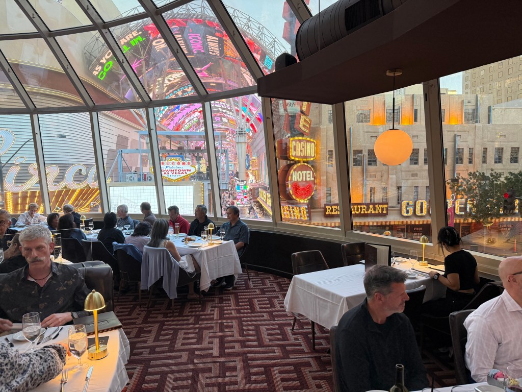
That Vegas is gone. Try finding a room on the Strip under $300 – especially after the resort fees, parking, and numerous other unbundling fees. Impossible. Jane and I stayed downtown at the Golden Nugget. Nice room but $300 per night? Not that nice. We could walk to the Fremont Experience – what is left of Fremont Street. Now it is more amusement park/theme park than it is a street. Not much of interest for me. I read somewhere that during the 1980’s, 80% of Las Vegas revenue was from gambling; now gambling is only 20%, the rest comes from entertainment, fine dining, shows, resort fees, $20 drinks, and $40 Starbucks orders (it was for two and included a couple muffins, but still!).
See Jane’s video of Fremont Street
We did spend one evening down on the strip. We had a forgettable dinner and saw one of the new Cirque Du Soleil shows, KA, which is the only show that fit our brief stay. It had the usual acrobatics, but was designed to tell some mythical story involving a young brother and sister. I found the story absolutely indecipherable (there was no dialog, just action and music), and the human feats overwhelmed by pyrotechnics, a stage that resembled a raft being tossed about in a hurricane, and music loud enough for my Apple watch to send me several alerts! Jane said she enjoyed it though…
I did a bit of gambling. Blackjack is now multi-decks only, with very unfavorable rules and lots of very bad side bets. I played some poker – I managed a small profit that didn’t quite make up for my donation at the BJ table. I broke even (nearly) on a couple of bets on the Cavs – Raptors game (lost the game but won the over), but my gambling budget turned black when the Guardians beat the Blue Jays on the point spread.
By far the most memorable experience in Vegas was our dinner at Oscar’s Steak House. Oscar’s was opened in 2011 by notorious mob defender and former mayor Oscar Goodman as a throwback to the Rat-Pack days. Originally it was known as Oscar’s Beef, Booze, and Broads. Oscar was not much interested in being PC. They’ve dropped that tag, but its cuisine is still very much old Vegas. My steak was done to perfection as was Jane’s and all the fixings were excellent. I had two delicious Martinis (Bombay and olives, shaken not stirred) that left me spinning. Jane said her creme brûlée was the best she ever had (and that is saying a lot!). All that for just over $300 for two.
I doubt I’ll return to Las Vegas in this lifetime.