Aches and Pains

Note: I am writing this in the evening of March 8, but have no internet connection, so I will post it when I do.

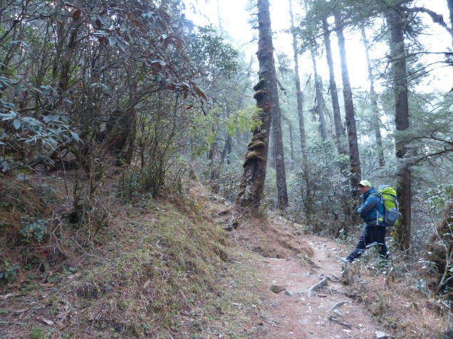
True to form, what looked like a relatively easy day on the map, turned out to be grueling. We began at Junbesi at about 2600 meters and climbed up and around one of the north-south ridges. Net gain was only about 300-400 m, but all the little ups and downs probably doubled that. Then it was down down down to another river-crossing via a long steel suspension bridge, then up for 1 hour to a small village for lunch, then up up up to Taksindu La (la = pass), a low spot in the next north-south ridge. Then came the grueling part. A 900 m plunge. While easing my way down the steep trail, I found out that the smallest appendage on my body can cause the greatest pain. No not that one…..my right pinky toe. That little bugger started jamming on the morning downhill section. A boot lace readjustment seemed to help my toe a little, but then my left achilles heal started to get stabbing pains – not fun, a snapped tendon would end the trek on the spot and require evacuation. The pain seemed to lessen on the way down, so hopefully a couple of NSAIDs will solve it.

F06414D6-EB2E-4CDF-9FA0-A40F8090136C
In spite of the gray weather, portions of the hike were through very pleasant forests.

To make a miserable day even worse, the afternoon clouds came again and the rain began. By the time we reached the hillside village of Nuntala, it was a steady downpour. I stood in the rain while Bhakda ran from lodge to lodge looking for rooms. The one he finally chose was distinctly NOT luxurious. The room had a 2 inch-thick mattress about half the size of a standard twin, and room enough beside it to turn around. The down-the-hall toilet was standard squat. No sink, no trash can, no shower, no warm wood stove. I think the night before must have put him over budget and this is a make-up.

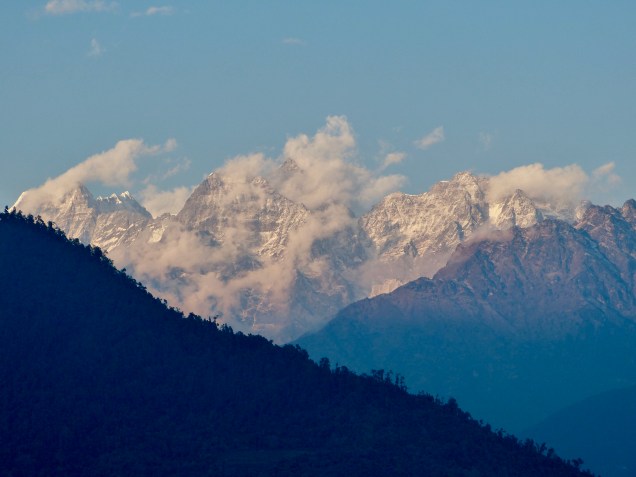
The highlight of the day cake just before sunset, when the clouds parted and gave us a glimpse of snow covered 6000 m peaks.

7A35BBE1-053F-44B2-B2C0-9B7BD44AEC0C
A sunset treat.

After a baby-wipe bath, and donning some warm, dry clothes, I felt much better. Down in the cold dining room, along with my usual pre-dinner hot tea, I was also offered a tasty plate of spicy buffalo meat.

Tomorrow, we finish the downhill plunge to the low point in the trek at 1500 m, so I have a 700 m downhill to negotiate with my bum feet in the morning. But my guide promises that tomorrow is any easy day; I would like to believe him….

Some scenes from the day’s hike.  Flowers were every where, terraced hillsides, and cute Sherpa kids.

Unexpected Luxury

Note: This post was written on March 7 but will be posted on a future day when I have a stable internet connection.

Today was a long day, so this will likely be a short post. We climbed over a high pass, Lamjura La, which is the highest we will be for several days. At 3500 m elevation (about 11,500 ft) the climate there is decidedly cooler. Small patches of what looked like relatively fresh snow flanked the trail. We arrived at a small tea house for lunch just below the pass at 11:00 am and with the sun, the temperature was quite comfortable. As we ate our lunch, clouds began building and the wind blowing. By the time we crossed the pass, the clouds had obscured the sun, and a stiff wind made it feel quite cold.

1F3BCD22-48F7-4ECC-993C-44E56AF57E3B
11,500 feet high but in the foothills. Lamjura Pass is in the distance.
BAA9C86E-7733-44AD-92E7-738BEA7764FB
Your hero at Lamjura La.

The descent down to the village of Junbesi was an endless slog down a deep valley. The start of our descent passed through a mossy, magical forest of pine and rhododendron. Farther down as we approached the Junbesi river, I was surprised to see road-building activity once again. This road came up the river from the south. Our trek is essentially a eastward march directly across the topographic grain defined by the southward flowing rivers draining the high Himalayas. Hence our route is 90 degrees to the topography and therefore intensely up and down. However, in the aftermath of the 2015 earthquake, the road-building frenzy utilized the north-south valleys to access these rural areas hardest-hit by the earthquake.

1843954D-F921-463D-BDBC-EE69200FECFA
It was a long slog down from the pass, but through some nice forest. Gokul, my porter, is for scale.

As we approached Junbesi from above, we could see the new road, passable but still under construction. Junbesi also had power from a generator downstream. The town is much more prosperous than the small villages along the ridge lines. Our accommodation for the evening, the Ang Chokpa lodge, was a very pleasant surprise. I got a large room with an attached bath AND hot water in the shower. I was even able to access a reasonable town-wide WiFi for about $5, although it went down before I could post this. I’m writing this sitting around the wood burning stove in the toasty common room while digesting my spaghetti dinner (a nice change from dal bhat). Tomorrow looks like a relatively easy flat day on the map, but I have learned that Nepali flat means up down up down up down….


Up and Down Up and Down

There is literally no place flat in the Himalayas, and today’s march from the jJiri to Bhandar proved the point. I climbed over two passes, through three villages, crossed one large river, and passed countless homes destroyed by the 2015 earthquake. My guide said it would take 6 hours, now I know to add 25% to his estimate as the old man factor. We left at 7:30 am, and arrived at Bhandar at 4:30. That included a 45 minute lunch stop at a small, dark lodge perched next to the trail.

Our lunch stop for the day.

The hike passed through pleasant pine forests, interspersed with small family plots growing wheat, rice and potatoes. All of the plots we terraced on the steep slopes. Most of the plots were only a 2-3 meters wide, with a drop of a meter or more down to the next terrace. My mind boggled at the though of how much labor this took, not to mention the DIY irrigation engineering.

6544B291-8745-4739-8334-CF938362EC40
Shivalaya.  The climb out of this village was brutally steep.

This region felt the brunt of the 2015 earthquake. Many (most) of the homes are made of stone and became piles of rubble. Now construction is rampant. In the aftermath of the earthquake, the government, inundated with foreign aid, went on a road building spree. Only a few years ago, getting to Bhandar involved exactly what I did today. Now two new roads service this town. These are only roads in the sense that one can navigate them by truck or 4×4.  They have been scraped into the hillsides, switch-backing up and over passes and down steep drops. My foot trail crossed one of these roads multiple times on the way up and over the day’s second pass. Ankle-deep dust on these roads meant I wore a silky tan coat by the time I arrived at Bhandar.

Many of the lodges have not yet been repaired in Bhandar, the one Is am staying in, Shoba Lodge, was built recently – out of wood instead of stone. I had a nice proud moment when I arrived at the lodge when the other trekkers staying here said they took 2 days to get here to my 1. I did a few imaginary fist pumps. Fortunately, the lodge had a gas hot water heater hooked up to a shower head, so I got the dust off me. Now I’m awaiting for my ration of dal bhat to arrive. I’m thinking I will sleep well tonight.

Highway of Death

I feel lucky to be alive tonight. I have survived the most dangerous part of my trek, the 200 km drive to Jiri. But let’s start at the beginning…

My guide, Bahkta and my porter, Gokul (who is a slightly darker version of the Marlboro man), met me at my hotel at 8:00. We also had a driver who I am pretty sure is in training for the Indianapolis 500.

img_0107
From the left, me, Mario Andretti, the Marlboro man, and Bhakti

Our car was a small Toyota sedan, and we all clambered in and headed out into Kathmandu’s traffic. I asked to sit shotgun, and man, was that a good choice! Bahkta and Gokul stuffed themselves in the back. The first hour was spent getting out of Kathmandu. On the outskirts of town we passed mile after mile of brick factories; the Nepalese were busily creating the tools for their own demise during the next big earthquake. The traffic was stop and go, mostly stop. Finally we emerged onto the the Aranko Highway, a route built by the Chinese in the 1960s that connects Kathmandu to the Tibetan border. After a couple of hours we branched off onto the B.P. highway, a new road built by the Japanese that connect Kathmandu to the southern lowlands.

Let me describe these roads: hair raising (if I had any), vomit inducing, ass-puckering and pee loosening doesn’t begin to do this route justice. Nominally 2 lanes, in reality it would be a generous bike lane in the US. Often, when a truck and a bus pass, both vehicles would slow to a crawl, and inch past each other with mm to spare, horns a-honking the entire time. The road climbed and fell, often with shear drop-offs. Guardrails? Who needs ’em! My driver drove like he was late for his wedding (more likely his funeral). With incredible skill he passed all manner of slower vehicles with inches to spare between us and oblivion. And all this describes the first half of our route.

About halfway, we made a quick stop for lunch – delicious dal bhat and curry.

E750B8E5-27E4-4F6E-8759-6EF718067947
A delicious lunch, Dal baht, the 24 hour fuel

Fear makes the best spice. After lunch, the route crossed a bridge and followed the Tampa Koshi River to the north. The road was now an ancient, nominally paved, single lane trail, pot-holed and washed out by floods over long sections. The road demanded 20-30 km per hour, my driver insisted on 50+ km per hour. Any on coming traffic was negotiated via a game of chicken; we won more than lost. The road then left the river and climbed, and climbed and climbed. Finally, we reached Jiri at 3:30 pm, for a 7 hour 30 minute time – probably my driver broke his own world-record. Jiri turns out to be a rather dismal village at the end of the road. Main Street is a wide but rough dirt road. We checked into a small Sherpa guest house. I bought my crew a beer, and we had another meal of dal bhat. I feeling at once excited and apprehensive about the coming trek. Tomorrow it begins.

Kathmandu

When I last visited in 1986, Kathmandu had a population of 400,000, today this exploding city is now an order of magnitude larger with over 4 million inhabitants. Today I toured some of the famous landmarks of the city with a driver and guide. Dubar square, a couple of famous temples, and a cremation site along the river.

4C5B74D2-8E96-4DD6-B8A5-BBD37107A2BE.jpeg
View of Kathmandu from Swayambhunath Temple

None of this impressed me much, but what did was the incredibly lasting impact from the earthquake that struck Nepal nearly 3 years ago. Over 9,000 people perished in that temblor, but it could have been far, far worse. The earthquake struck at noon on a Saturday which is Nepal’s Sunday. Schools were closed, children were out playing in the streets and parks, and businesses were shuttered. But the property lose was unbelievable. My driver said that in his village only a single house was left standing and that house became a field trip stop for building engineers. Bricks are everywhere. Piles of recycled brick, neat stack of new bricks, and many piles of broken bricks that no one has yet bothered to haul away. Construction is everywhere, yet still has so so far to go. Dust. Oh the dust. A perpetual yellow haze hangs over the city and coats everything left outside. In spite of all this, the tourist district is bustling again; Nepal is open for business.

Scenes from a shaken city

The drive today also reminded me how aching poor Nepalis are. The homeless are everywhere and by comparison the cardboard shacks inhabited by SoCal’s homeless seem like palaces. My tour guide said that over the last 10-20 years, there has been a mass migration from rural Nepal to the city where hopes for a brighter future collided with the harsh reality. Yet in the face of hardship, the Nepalis remain upbeat. My tour guide talked proudly of how Nepal is now a democracy after years of incompetent governance in a country run by kings.

I spent the late afternoon completing my supply shopping, and having a last beer and pizza in relative civilization. Tomorrow morning I will be drive about 185 km (8 hours!) on the Araniko Highway, arguably the most dangerous section of road in the world. I checked it out on Google maps and all I can say is that I hope I can ride shotgun.

The Adventure Begins: Bangkok to Kathmandu

After 32 years, I have finally returned to Kathmandu. I left Bangkok about 11 am after stuffing myself with 3 Krispy Kreme donuts and a cup of Starbucks (my waistline hopes they never open a KK franchise in Chiang Mai, the rest of me does). My flight was delayed by about an hour as we entered a holding pattern south of the city, then waited another 30 minutes on a taxiway while waiting for a parking spot. Although my memory has faded, it seems that not much has changed at Tribhuvan International Airport, it is still tiny and rather chaotically ad hoc. The trekking company I booked with had a driver dutifully awaiting my late arrival, and we drove slowly through the dusty, dusty streets, lined by piles of debris and bricks seemingly still leftover from the Earthquake 3 years ago. I arrived at the small botiqueish Dom Himalaya hotel in about 30 minutes. I was warned to tell the front desk 5 minutes before I showered so that the could turn on the hot water. Yes, I’m back in the third world.

With the remainder of the day free, my first step was to find an ATM. Here’s where my adventure began. My transaction went normally until the screen said “take your cash”, then it flashed “transaction cancelled”. My card reappeared, but before I could grab it, the machine slurped it right back inside. Then the screen reset to “please insert your card”. I could almost see that damn machine smile at me for offering such a tasty morsel. To make matters worse, I got an email from my bank in the US notifying me that I had just withdrawn 35,000 rupees or about $340. So now I am standing there with no rupees, no ATM card, and the bank had just closed 15 minutes prior. I was forced to dip into my emergency dollar cash reserve, which I was able to change into rupees at a nearby money changer. I guess I’ll be waiting at the bank door at 10 am tomorrow morning.

I spent the rest of the afternoon and evening getting a local SIM card, and picking up some odds and ends for my trek. Kathmandu is very different than I remember it. Back in 1986, the streets of the city had more sacred cows than cars. Now the cows have apparently been banished to be replaced by a cacophony of sacred cars and motorcycles. One nice thing though, the main part of the Thames area is a maze of walking streets, no cars. That made for a very pleasant shopping stroll amongst the myriad of small shops selling trekking gear. I finished the evening with a fine meal of Indian food at the Third Eye Restaurant.

A romantic candlelight dinner for one in Kathmandu.

Hiking in the Jungle

Almost to the date, 32 years ago, I set out on a 3+ week trek around Annapurna, in the Himalayas Mountains of Nepal.  Next week, I will return to Nepal to begin a 3+ week trek to Everest Base Camp, with a side trip to Gokyo Lakes.  To make this new trek even more fun, I will begin my walk from Jiri instead of flying into Lukla.  This will add an additional week to the trek as I hike the original approach to Namche Bazaar, the gateway to the Everest region.

During that first trek so long ago, I trained by lying in the sun, drinking beer, and otherwise cavorting around Thailand for three weeks before arriving in Kathmandu.  My now 62 year old lungs and legs would have little chance in Nepal if I followed the same training regime this time around.  So, for the last few weeks, I have been hiking the jungle trails up and down Chiang Mai’s Doi Suthep – Doi Pui Mountain.

From Chiang Mai city, Doi Suthep Mountain appears as a large completely forested hulk, with the famous Doi Suthep Temple perched on a promontory about 2000 feet up.  The temple is serviced by a well-travelled, paved road plied by fleets of buses, fans, and songtaews that ferries 1000’s of tourists up to the temple every day.  Only a handful of people take the direct route, up the walking trail.  The first part of the trail, known as the monk’s trail, begins at the mountain’s base, and proceeds up to a lesser known temple, Wat Pha Lat, perched about 700 ft above the trailhead.

IMG_4285
A trail-side shrine at Wat Pha Lat

From there, the “trail” makes a direct beeline for Doi Suthep temple sans switchbacks.  This being the dry season in Thailand, the trail consists of a series of steps stomped into the hard clayey soil.  During the rainy season, I imagine that the trail would make a great muddy waterslide; temple to trailhead to hospital in 5 minutes!

I have now been up and down this trail many times – I know every root and rock along the way – I’m pretty sure I could navigate the trail blindfolded.

Yesterday, as an alternative, I chose a very lightly used trail that diagonals up the mountain toward the northwest to the small hill-tribe village of Ban Khun Chang Kian (บ้านขุนช่างเคี่ยน) a small settlement spilled across a high ridge about 3000 ft above the City.

IMG_4529
Your grizzled hero at Ban Khun Chang Kian

The trail is mostly used by mountain bikers who get hauled up the mountain in the back of pick-up trucks, and then come tearing down the trail, hikers beware.  I also saw a couple of crazy farang trail runners – not many hikers though,  mostly the trail is empty and quiet.

From the village, I traversed about 9 km south to Doi Suthep temple, following a four-wheel drive road that led eventually to a poorly maintained trail.  The first part of the traverse passed by numerous strawberry fields that thrive in the cooler mountain-top environment.  Trail finding was a bit of a challenge – the jungle hides a spider’s web of jeep trails and walking paths going every-which-way.  After climbing over what seems like 100s of fallen trees, I arrived at the bustle of Doi Suthep and descended the steep trail to just above Wat Pha Lat, where I finished the 20 km long hike with a 3 km traverse back to my parking spot along the Doi Suthep road.

IMG_4534
Terraced strawberry fields forever

Hiking this trail gave me a great workout – the distance and elevation gain probably equals or exceeds any day-long segment I will encounter in Nepal (albeit at low altitude).  The trails are pleasant enough, although quite steep in places.  During the dry relatively cool season (temps in the upper 80s- low 90s F) the cooler temperatures up high are pleasant. There were only two real downsides to this hike.  One was the constant cloud of kamikaze gnats that enveloped my head.  These terrorists had a penchant for exploring any orifice of mine they could find, and apparently they thought my eyes were portals to a bug’s paradise.   I spent much of the hike wondering if the swarm consisted of the same 200 bugs who found me at the trailhead and followed me for 20 km, or whether they were a tag-team outfit that each had their own designated section of trail.  I imagined attaching a nano GPS transmitter to a few of the gnats to answer this question.  Such are the thoughts that occupy my feeble brain when my legs and lungs are on autopilot.

The second downside was the 20-30 inevitable spider-web-face-plants.  A face-first meeting with this guy will get your attention!

IMG_0078

I am hopeful that these forays into the Thai jungle will amply prepare me for the hiking in Nepal.  My next post will likely be next week from Nepal….