Last night I had a bit better sleep. I still had some episodes of suffocation, and spent the first half of the night cough badly. The cough subsided finally and I got a couple of hours of sleep. Before getting out of my sleeping bag I decided to take a rest day today. This rest day most likely means I will have to cancel the add-on part of the trek to Gokyo Lakes, which is probably for the best the way I’m feeling anyway. I will focus on getting to Everest Base Camp and then see what happens.
Given that I am having issues with altitude at Namche Bazar at only 11,500 ft, I will need to proceed slowly and with caution. I have plenty of time, my flight from Lukla back to Kathmandu is not until the 26th of March, 11 days for what is normally a 8-9 day trek to base camp from Namche. One day at a time.
I spent the day mostly lying in my sleeping bag, doing NYT crossword puzzles and dosing off and on. I had only minor episodes of the periodic breathing that plagued me the last 2 nights. Additionally, I’ve started taking Diamox, the recommended drug for the prevention of altitude sickness. Downside is it makes you pee a lot. Won’t be fun getting out of a warm sleeping bag a few times every night.
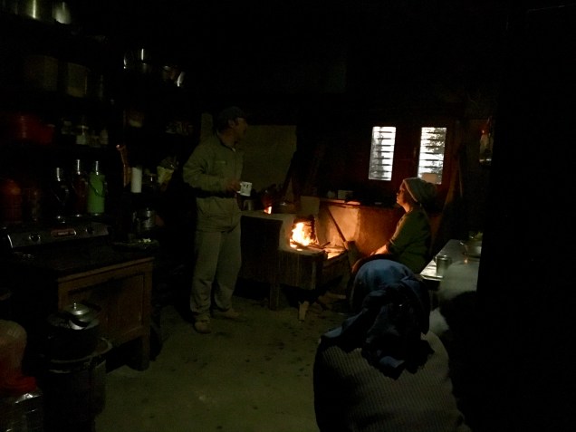
Gokul, Bhakta and me sitting around the heater. What you can’t see is that behind the camera WrestleMania is on the big screen TV behind me.
Its now evening and I’m sitting around the electric heater (only source of heat in the building) with Bhakti my guide, and Gokul, my porter. They take care of my every need, and I am confident I am in good hands.
Just when I thought I was better and was handling the altitude, Wham! I had the most miserable night so far on this trip. Every time I just about fell asleep, I would be slammed awake with the feeling of suffocating. I few deep breaths later, and I was fine…and wide awake. This is actually a normal response to a fast increase in altitude. The panting of climbing in the thin air reduces ethe amount of carbon dioxide in your blood. Since breathing is mostly to get rid of carbon dioxide, the brain signals your body to slow or even stop breathing. When your oxygen level then also falls, your brain says: oops! and you gasp for air. In addition my cough and sore throat got worse through the long night. By the time it was ready to get breakfast and go on an acclimatization day hike, I was already exhausted.
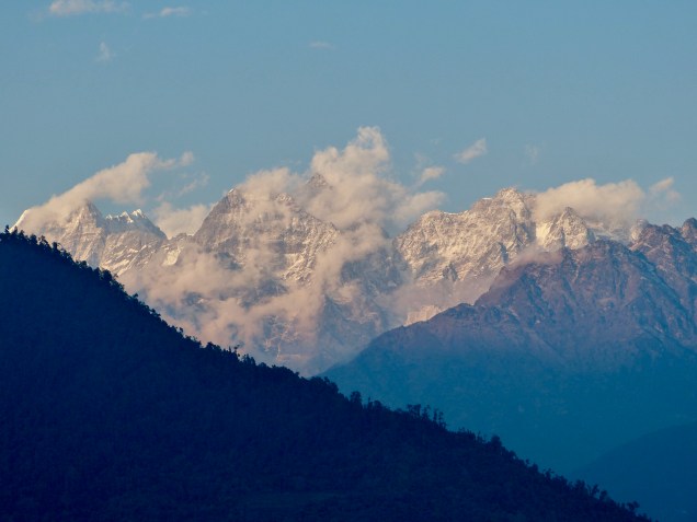
Namche Bazar from above
The route of the day hike took us straight up about 400 m above Namche Bazar. Every step was a chore. I started counting 25 steps, then resting. I stuck with it, and eventually I rose above the village, and dramatic peaks began to emerge. I reached the dirt air strip far above town which is the highest airstrip in the world, although now it is seldom used.
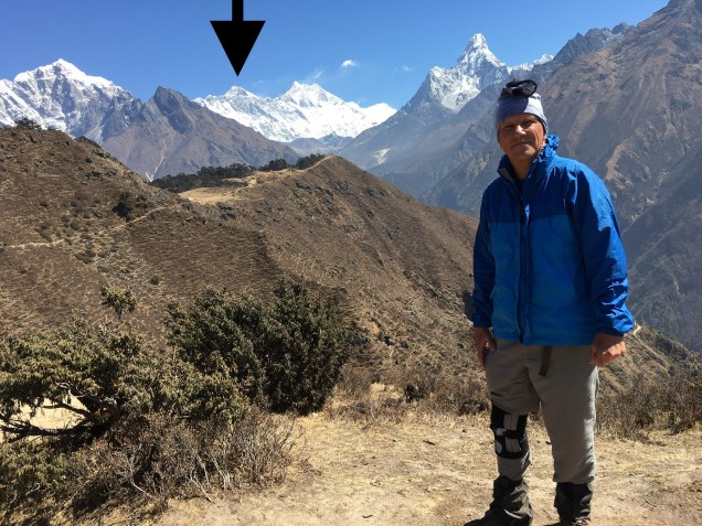
Our goal was a lodge situated on the hill above Namche at 3850 m, with views up the Khumbu Valley. Sure enough, I rounded the corner of the lodge where a magnificent view of Mount Everest, Lhotse and Ama Dablam appeared. We spent 20 minutes or so admiring and photographing the view, before heading back down. The return trip was much faster.
My first view of the tip of Mount Everest and Ama Dablam Mount Everest close up. It’s a little windy up there.
I spent the remainder of the day resting, doing some shopping for minor supplies, and having a coffee and brownie at Himalayan Java. My cough has not subsided, so I am seriously spending an additional day here at Namche. Hopefully with a good night’s rest, I will be good to go.
What a difference a good night’s sleep makes! I went to bed the night before thinking I might have to take a day off to let my feet heal and my cold to subside. The night before I got the tea house to fill one of my water bottles with boiling water, and I put that in my sleeping back. I was toasty warm and slept very well. I woke up still coughing some, but felt energized enough to get back on the trail.
Today we made the climb up to the famous Sherpa trading post of Namche Bazar. The day dawned with a bright blue sky.
As we walked up the river, we began to see some magnificent peaks.
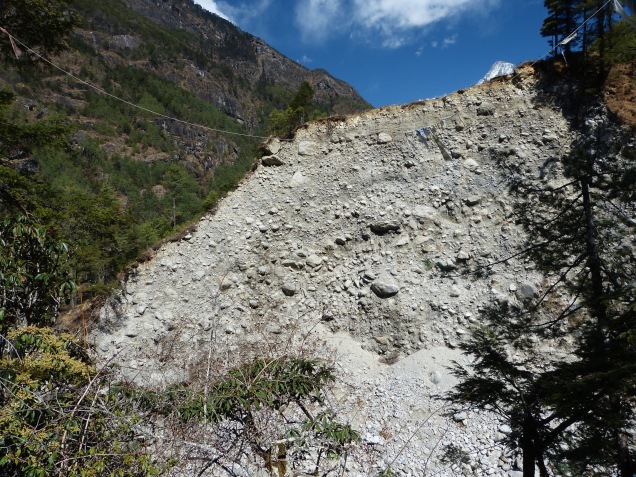
The trail continued to follow the Dudh Koshi River northward, staying close to the valley bottom. We passed a series of villages catering to the hordes of trekkers heading toward Everest Base Camp. As we approached one of these villages from below, I realized we had reached a significant milestone: The end moraine of the Wisconsin glacier in the Dudh Koshi Valley. It was pretty hard to miss actually as we had to climb to its top to reach the next village.
Glacial till – the first I have seen. Presumable from the maximum glacial advance of the last ice age.
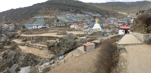
Just north of Monjo, another trekkers’ village, a significant tributary, the Bhoti Koshi River, enters from the northwest, and Namche sits high above the “V” made by the intersection of the two streams. The trail was surprisingly graded, with many switchbacks, and crossed the main valley on a dizzying suspension bridge. I felt pretty good thanks to having lived at or above 2300 m for the last week. I reached Namche, elevation 3440 m (about 11,400 ft) by 3 pm, well ahead of schedule.
Namche Bazar
Namche is a large and hugely prosperous village catering to the trekkers. Shops, cafes and bars line the narrow streets. There is even an Irish pub here, touted as being the highest in the world. I am planning on visiting for a high altitude Guinness on my return nearly 2 weeks from now. Tomorrow is an acclimatization day, we will do a short day hike to a higher altitude, but sleep in Namche again. Hopefully this nagging cough subsides soon.
Last night, spent in the small village of Paiya in the Bee Hive Lodge, was one of the longest nights of my life. I went to bed pretty early, about 8 pm, after a dinner of Sherpa stew, a tasty rice and vegetable glop. My room felt bitter cold and very damp. It was made of stone with a door, two tiny windows, and two tiny beds with very thin mattresses. I couldn’t get warm, even though I have a -10 degree C sleeping bag and my thermometer said it was about +10 C. I tossed and turned until I had to pee, which meant going outside, sown some steps, and into the dark squat toilet. Finally I drifted off. In my fitfull sleep I dreamt that I woke up and it was pitch black and I had no idea where I was, and I had no idea where any lights were. It was if I had gone totally blind. Then I awoke for real and it was pitch black in that cave of a room, and I had a for-real panic attack, complete with hyperventilation and silent screams. Slowly I came to the realization of where I was and where I kept my headlamp under the pillow. Turning on the headlamp only slightly eased my panic. I spent they rest of the night tossing and turning trying to breathe normally. The thin mattress let the cold in from below and added to my sense of doom. I almost fell asleep when it was time to get ready for another day of hiking.
The Dudh Kosi is down there somewhere, you can see my trail in the upper left.
The day’s hike was pure misery in spite of some spectacular scenery. Not enough sleep together with my lingering cold that was threatening to turn into a cough made the going very slow. By mid morning the rain began. Our route contoured high on the north slope of the Dudh Kosi River, then plunged down 700 m to cross a tributary stream, then back up 400 m.
This rugged region is incredibly populated.
Soon we came to the intersection of the trail down from Lukla, where 95% of the trekkers fly into. Suddenly, my lonely trail, that had been populated by more donkeys than humans, became a virtual superhighway of trekkers fresh in from Kathmandu on the flight into Lukla. We ate an early lunch, then made the long trek northward to Pakding, a large trekker’s town of nothing but tea houses. My tea house is large, with a gas hot shower, and a very large heated dining room. I splurged on a coke for nearly $3.50 to go with my dinner of chicken nuggets and French fries. I’m in a much nicer room tonight so I am hopeful I will avoid a repeat of the panic attack.
The rain stopped today long enough to grab one picture.
Note, I am writing this post on March 10 USA time, March 11 in Nepal. I have WiFi at my tea house tonight, but is way to slow to do anything but check email. I will post this when I get a good internet connection (Might be Kathmandu).
Today I awoke feeling miserable. My nose was running – a full blown cold. The weather added to the misery, clouds floated amongst the surround peaks, and valley below me. A light drizzle was falling as I got my self ready for another day of walking.
On the map, todays hike looked like an easy day with no serious climbing. My goal for the day was Paiya, really a series of stone buildings scattered along the trail which contours high on the east slopes of the Dudh Kosi River. I have learned that the trekking map I am using is not very accurate. Today we climbed and climbed and climbed. Instead of contouring we were climbing up and around east-west ridges between the tributaries entering the Dudha Kosi from the east. Every time we would come around one of these ridges, I thought we would level out, but instead I would see the trail climbing high onto the next ridge. In the end, we gained over 1000 m in elevation, only to give back 300-400 m as we descended into a tributary valley where Paiya lies.
As we rounded the last ridge, Paiya appeared across a tributary valley. It looked quite close, maybe 20 minutes walk. My guide said 2 hours! I soon found out why. The descending trail was on a very wet, north-facing cliff face, and carved into the gneissic rocks, in places making a C-shaped notch. The path was a jumble of angular rocks imbedded in mud formed from the rain and donkey piss. Mostly piss. I had to easy my way down stepping from angular stone to slippery angular stone. One misstep and the best I could hope for was a face plant into donkey poo. If I went over the edge, the vegetation might slope me down a bit, but the rocks a 1000 ft below would stop me. In places the trail was only about 2 feet wide. The rain kept my camera in my pack the entire day, I think I took one picture.
We are now sitting around the wood burning stove at the Bee Hive lodge. We were treated to locally grown, fresh pop corn, the best I have ever tasted. Looking forward to my dinner of Sherpa stew.
Note that this post is being written on March 9 (actually March 10 here). The internet is glacial here so I will post this at the first opportunity.
Today actually was a pretty short day, as promised by my guide. Our route took us down down down from the last major north-south ridge. We ended up at the Dudh Kosi River, the major river running south from the Everest region. At the bridge we were also at the lowest point of the trek at 1500 m, lower by 500 m than where we started! Upon crossing the river on a long suspension bridge, our trail turned north.
Crossing the Dudh Kosi, then it’s a left turn toward Everest
No more up and over high ridges, from there the route follows the river up stream towards Everest. There will still be plenty of ups and downs, mostly ups; I have about 4000 m (more than 2 1/2 miles) of vertical elevation to gain to reach Everest base camp.
The Dudh Kosi River
An update on my health. My legs seem almost fine now, my little toe is still firmly attached and not causing any trouble, my left heal is much better thanks to a morning taping job and a strong dose of anti inflammatory. However I seem to be catching a cold, my throat is sore, and I am a beginning to get stuffy. Fortunately my cold is happening now, during some relatively easy days, and not up at high altitude.
My tea house for the evening is in Kharikhola, perched high on the east slope of the Dudh Kosi River. I was able to take a hot shower, which felt nice after hiking the last hour up to here in rain. I’ll keep this post short so I can get some rest and hopefully chase away this cold.
Note: I am writing this in the evening of March 8, but have no internet connection, so I will post it when I do.
True to form, what looked like a relatively easy day on the map, turned out to be grueling. We began at Junbesi at about 2600 meters and climbed up and around one of the north-south ridges. Net gain was only about 300-400 m, but all the little ups and downs probably doubled that. Then it was down down down to another river-crossing via a long steel suspension bridge, then up for 1 hour to a small village for lunch, then up up up to Taksindu La (la = pass), a low spot in the next north-south ridge. Then came the grueling part. A 900 m plunge. While easing my way down the steep trail, I found out that the smallest appendage on my body can cause the greatest pain. No not that one…..my right pinky toe. That little bugger started jamming on the morning downhill section. A boot lace readjustment seemed to help my toe a little, but then my left achilles heal started to get stabbing pains – not fun, a snapped tendon would end the trek on the spot and require evacuation. The pain seemed to lessen on the way down, so hopefully a couple of NSAIDs will solve it.
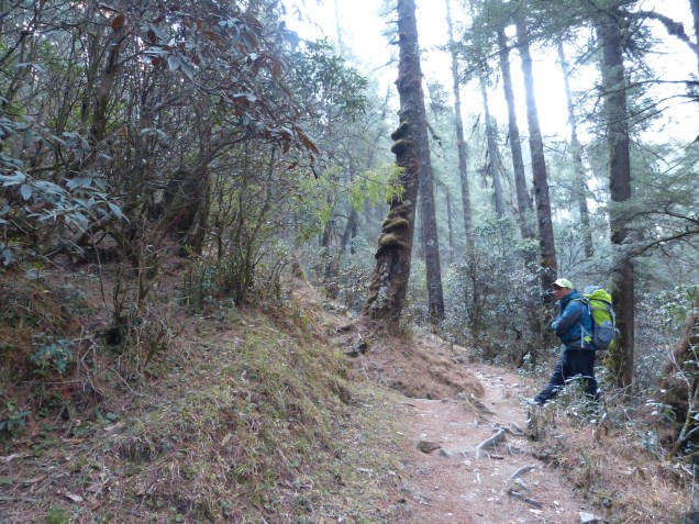
In spite of the gray weather, portions of the hike were through very pleasant forests.
To make a miserable day even worse, the afternoon clouds came again and the rain began. By the time we reached the hillside village of Nuntala, it was a steady downpour. I stood in the rain while Bhakda ran from lodge to lodge looking for rooms. The one he finally chose was distinctly NOT luxurious. The room had a 2 inch-thick mattress about half the size of a standard twin, and room enough beside it to turn around. The down-the-hall toilet was standard squat. No sink, no trash can, no shower, no warm wood stove. I think the night before must have put him over budget and this is a make-up.
The highlight of the day cake just before sunset, when the clouds parted and gave us a glimpse of snow covered 6000 m peaks.
A sunset treat.
After a baby-wipe bath, and donning some warm, dry clothes, I felt much better. Down in the cold dining room, along with my usual pre-dinner hot tea, I was also offered a tasty plate of spicy buffalo meat.
Tomorrow, we finish the downhill plunge to the low point in the trek at 1500 m, so I have a 700 m downhill to negotiate with my bum feet in the morning. But my guide promises that tomorrow is any easy day; I would like to believe him….
Some scenes from the day’s hike. Flowers were every where, terraced hillsides, and cute Sherpa kids.
Note: This post was written on March 7 but will be posted on a future day when I have a stable internet connection.
Today was a long day, so this will likely be a short post. We climbed over a high pass, Lamjura La, which is the highest we will be for several days. At 3500 m elevation (about 11,500 ft) the climate there is decidedly cooler. Small patches of what looked like relatively fresh snow flanked the trail. We arrived at a small tea house for lunch just below the pass at 11:00 am and with the sun, the temperature was quite comfortable. As we ate our lunch, clouds began building and the wind blowing. By the time we crossed the pass, the clouds had obscured the sun, and a stiff wind made it feel quite cold.
11,500 feet high but in the foothills. Lamjura Pass is in the distance.Your hero at Lamjura La.
The descent down to the village of Junbesi was an endless slog down a deep valley. The start of our descent passed through a mossy, magical forest of pine and rhododendron. Farther down as we approached the Junbesi river, I was surprised to see road-building activity once again. This road came up the river from the south. Our trek is essentially a eastward march directly across the topographic grain defined by the southward flowing rivers draining the high Himalayas. Hence our route is 90 degrees to the topography and therefore intensely up and down. However, in the aftermath of the 2015 earthquake, the road-building frenzy utilized the north-south valleys to access these rural areas hardest-hit by the earthquake.
It was a long slog down from the pass, but through some nice forest. Gokul, my porter, is for scale.
As we approached Junbesi from above, we could see the new road, passable but still under construction. Junbesi also had power from a generator downstream. The town is much more prosperous than the small villages along the ridge lines. Our accommodation for the evening, the Ang Chokpa lodge, was a very pleasant surprise. I got a large room with an attached bath AND hot water in the shower. I was even able to access a reasonable town-wide WiFi for about $5, although it went down before I could post this. I’m writing this sitting around the wood burning stove in the toasty common room while digesting my spaghetti dinner (a nice change from dal bhat). Tomorrow looks like a relatively easy flat day on the map, but I have learned that Nepali flat means up down up down up down….
Note: I am writing this on March 7, but I am now well off the grid, so I will be posting this at some future date).
I awoke this morning at 3:20 am, partly because I went to sleep at 9 pm the night before. I was quite knackered from the long previous day going over two passes. Of course, I had to pee. Which brings me to the subject of tea houses.
The tea house at Sete
Many are also known as lodges. They are generally stone building, one to two stories, that double as a family’s (or two or three) home. This section of trail is sparsely populated by trekkers, therefore the lodge business is distinctly secondary to other means of income and subsistence, mainly farming. They provide the most basic of accommodations, generally a very small room with 1-3 beds crammed in. The floor is bare wood, the mattresses are an inch or two thick, and if they have the luxury of electricity, there will be a dim light hanging from the ceiling. Toilet facilities (basic Asian squat) are down the hall, or in the present case, down the steep wooden stairs.
So back to peeing, by the time I was done getting out of my warm sleeping bag, finding my shoes in the dark, clambering down the stairs and back up, I was wide awake. After all I had already had 6+ hours of sleep, in most cases sufficient for me. So I spent the rest of the wee hours reading the news (at the time I still had a cell connection), trying to sleep again, and completing yesterday’s blog post.
Today we climbed a mountain, in reverse. We started by following a small stream downhill to the east, eventually emerging high on the north canyon wall of the Likhu Khola. Just across the side valley from us was a flurry of road building, with tight switchbacks being built on a nearly vertical wall. It turns out that this will be the service road for a Chinese-financed dam and hydroelectric power plant on the Likhu Khola. Given the narrow canyon at this point, it seems like an ideal site. Before you yell environmental foul, think about what life would be without power. This power plant will be a godsend for the people of this area that lived without power or roads when the earthquake hit.
The new road across the valley wind Ying it’s way down to the Power Plant site
The trail gradually descended to the east finally getting down to the river at the village of Kinja. This was the final destination of the road. After a brief rest and a check-in at the Khumbu district office, the trail southeast and straight up. We were now in Sherpa territory. We regained all the elevation we lost in the morning, and then some, finally arriving at Sete, perched high above the valley, at 3:00 pm. Sete, as far as I could see, consists of a couple of tea houses, nothing more. Our station for the night is the Sherpa Guide Lodge, owned by a school teacher. The school is apparently located a 20 minute walk away, so we had to await his arrival at 4 pm to check-in.
Enter a captionNew bridge being constructed across the Likhu Khola
Now, I am sitting in the owner’s kitchen, together with my crew, and various undefined members of the extended family, mostly because it’s warm in here, if a bit smokey. They are all speaking animatedly in Nepali, which always sounds to me like they are fighting. I mentioned this to my guide, and he said it’s because they are all drinking their home-made brew. Oh yea, I had to try it! They poured me a small milky looking glass out of what looked like a tea kettle. The taste wasn’t unpleasant. Of course they drink it warm and uncarbonated. Apparently they make it from wheat, although it didn’t taste anything like a wizen. It also had small round floaters in it that looked like small bugs, apparently some kind of spice they add to it. I would gladly drink more, but I didn’t given that I am trying to acclimate to the altitude – which here is 2500 m, or roughly 8200 ft.
Dinner with the fam.
Tomorrow we climb over the highest point this side of Namche Bazar, a high pass of 3500 m (11000+ ft). I’ll likely be in bed by 9 again tonight, hopefully for a longer sleep than last night.
There is literally no place flat in the Himalayas, and today’s march from the jJiri to Bhandar proved the point. I climbed over two passes, through three villages, crossed one large river, and passed countless homes destroyed by the 2015 earthquake. My guide said it would take 6 hours, now I know to add 25% to his estimate as the old man factor. We left at 7:30 am, and arrived at Bhandar at 4:30. That included a 45 minute lunch stop at a small, dark lodge perched next to the trail.
Our lunch stop for the day.
The hike passed through pleasant pine forests, interspersed with small family plots growing wheat, rice and potatoes. All of the plots we terraced on the steep slopes. Most of the plots were only a 2-3 meters wide, with a drop of a meter or more down to the next terrace. My mind boggled at the though of how much labor this took, not to mention the DIY irrigation engineering.
Shivalaya. The climb out of this village was brutally steep.
This region felt the brunt of the 2015 earthquake. Many (most) of the homes are made of stone and became piles of rubble. Now construction is rampant. In the aftermath of the earthquake, the government, inundated with foreign aid, went on a road building spree. Only a few years ago, getting to Bhandar involved exactly what I did today. Now two new roads service this town. These are only roads in the sense that one can navigate them by truck or 4×4. They have been scraped into the hillsides, switch-backing up and over passes and down steep drops. My foot trail crossed one of these roads multiple times on the way up and over the day’s second pass. Ankle-deep dust on these roads meant I wore a silky tan coat by the time I arrived at Bhandar.
Many of the lodges have not yet been repaired in Bhandar, the one Is am staying in, Shoba Lodge, was built recently – out of wood instead of stone. I had a nice proud moment when I arrived at the lodge when the other trekkers staying here said they took 2 days to get here to my 1. I did a few imaginary fist pumps. Fortunately, the lodge had a gas hot water heater hooked up to a shower head, so I got the dust off me. Now I’m awaiting for my ration of dal bhat to arrive. I’m thinking I will sleep well tonight.